About
Visualizing Early Baltimore is a fully three-dimensional, interactive digital model of Baltimore circa 1815 that provides connections between the past and today. The IRC has been working on various aspects of this digital visualization since 2012, combining historical research with cutting-edge modeling and mapping technologies to re-create an accurate 3D model of the city, its terrain, land use, and buildings in the early 1800s. The Bicentennial of the War of 1812 provided a catalyst and funding for the IRC to use the experience gained from its Visualizing Early Washington, D.C. project to develop this accurate map and 3D depiction of the Baltimore cityscape shortly after the famous bombing of Fort McHenry that inspired the words of the Star-Spangled Banner.
With fundamental support from the Maryland Historical Society and its network of scholars, the IRC collected the data necessary to initiate the visualization. The research effort also received significant support from the Maryland Division of Tourism’s 1812 Bicentennial Commission and the Robert W. Deutsch Foundation.
The IRC worked with GIS experts in UMBC’s Center for Urban Environmental Research and Education (CUERE) to create an accurate topography for the city’s construction. The project team researched the correct maps to use, as verified by scholars, and geo-referenced them to existing coordinate systems. Along with a typical 2D map, this became the base map for creating the visualization. The six-month effort resulted in an accurate 3D digital elevation map (DEM) of the original landscape of the city in 1815. The IRC also consulted local historians and did extensive research to determine where specific buildings existed back then and how they would have appeared. With that information, a team of IRC artists modeled and textured the buildings, wharves, and other structures that defined Baltimore during the economic and population boom that accompanied the height of the harbor’s role in commerce, privateering, and shipbuilding.
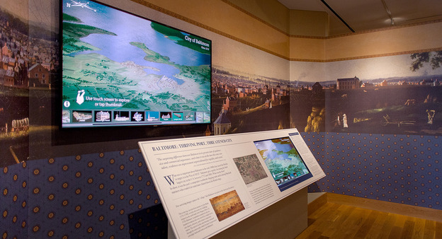
In September 2014, the first and major phase of this effort opened to the public at the Maryland Historical Society during their bicentennial commemoration of Baltimore’s pivotal role in the War of 1812. The main feature was an interactive kiosk entitled The BEARINGS of Baltimore, that anchored the Society’s exhibition In Full Glory Reflected: Maryland during the War of 1812.
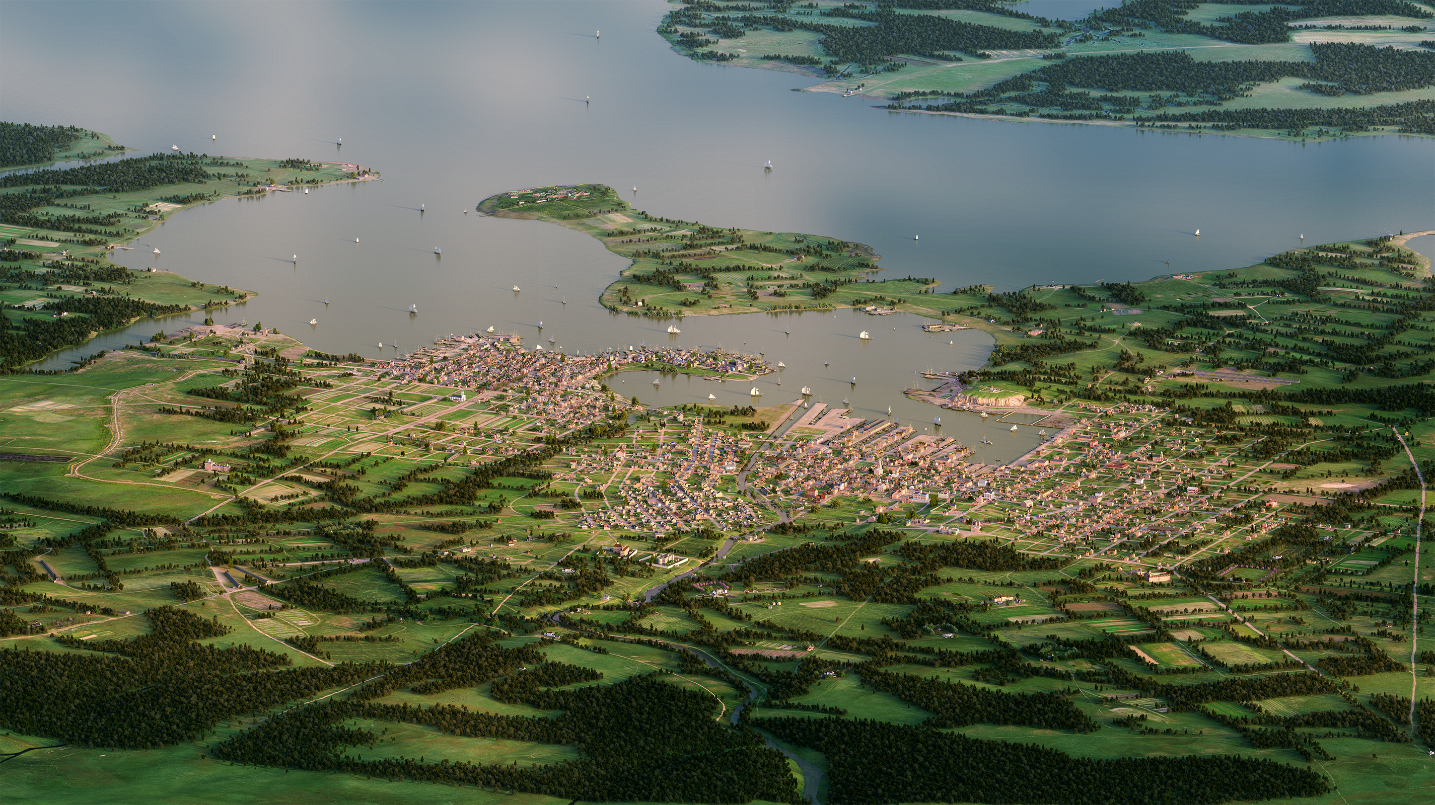
The BEARINGS of Baltimore is a gigapixel (2.5 billion pixels) image of a bird’s eye view of early Baltimore. IRC computer programmers have made this scene navigable online by using a touchscreen to zoom into the vast details of the city. Certain “hot spots,” such as the home of Mary Pickersgill, the seamstress who sewed the famous “Star Spangled Banner” for Fort McHenry, or the observatory atop Federal Hill signaling which merchant ships were headed to dock, can be located by tapping thumbnails, and additional information and visuals provided by the Maryland Historical Society can be found by accessing pop-up windows.
Additionally, the first public utility company in the United States was formed in Baltimore in 1816. For the public launch 200 years ago, the company laid pipes and installed gas lights in the Peale Museum (the first science museum in the United States), the Holliday Street Theater, and a street light on Baltimore Street. In 2016, for the 200th anniversary of this event, the Baltimore Gas & Electric Company (BGE) commissioned the IRC to refine this area of the early city and create a night scene showing the first gas lights in Baltimore. This type of illustration work highlights the strength of this research effort: With a fully accurate 3D model of the early city, any content can be created and rendered from any viewpoint.
In 2018, Anne Sarah Rubin was awarded a UMBC Strategic Award for Research Transitions, which allowed our team to do preliminary work on Slave Streets and Free Streets. This included pulling together databases of newspaper advertisements, census data, tax records, and city directories. It also allowed us to build the preliminary website which is our work sample. To date, we have been focusing on the Fells Point neighborhood, and we have placed dozens of re-discovered free blacks and enslaved workers on the map. We have also begun mapping sites of the slave trade, drawn from a sample of newspaper advertisements. Finally, we have begun mapping locations associated with fugitive slaves. This work has enabled us to identify our prototype narrative threads, and we look forward to continuing to build our databases and tell new stories.
Since 2012 UMBC’s Imaging Research Center (IRC) has worked to build a vivid recreation of how Baltimore would have looked between 1815 and 1820. This effort has resulted in the projects shown below, and the work continues.
BEARINGS of Baltimore, Circa 1815
Interactive Touch Screen Display, Maryland Historical Society – Click here
BEARINGS of Baltimore, Circa 1815 is an interactive 2.5 billion pixel image that visualizes Baltimore City in 1815 – right after the attack by the British. UMBC’s Imaging Research Center, in collaboration with the Maryland Historical Society and its network of historical scholars, has created an interactive touch-screen display at the Historical Society that allows viewers to tour the early city and understand its history. This tour is also available online here. This project was funded with generous support from the Robert W. Deutsch Foundation and the Maryland Division of Tourism 1812 Bicentennial Commission.
NOTE: This online tour works best in Google Chrome.
Slave Streets Free Streets
Visualizing the Landscape of Early Baltimore

Slave Streets, Free Streets: Visualizing the Landscape of Early Baltimore builds on the BEARINGS of Baltimore by using the landscape map as a story-telling medium. We bring Early Republic Baltimore to life by focusing on the city in which approximately 4,300 enslaved and 10,300 free African Americans lived and worked. Questions of slavery and freedom were enmeshed in the landscape of Baltimore. This project investigates four interconnected themes: the lives of free blacks, the lives of enslaved workers, the sites and workings of the slave trade, and stories of fugitive slaves, who ran both to and from Baltimore. Drawing on records such as city directories, tax records, census reports, newspapers, and other historical documents, we are re-discovering people, including free and enslaved residents, at locations around the city, and tying them by name to specific addresses.
The Founding of the Baltimore Gas Electric Company
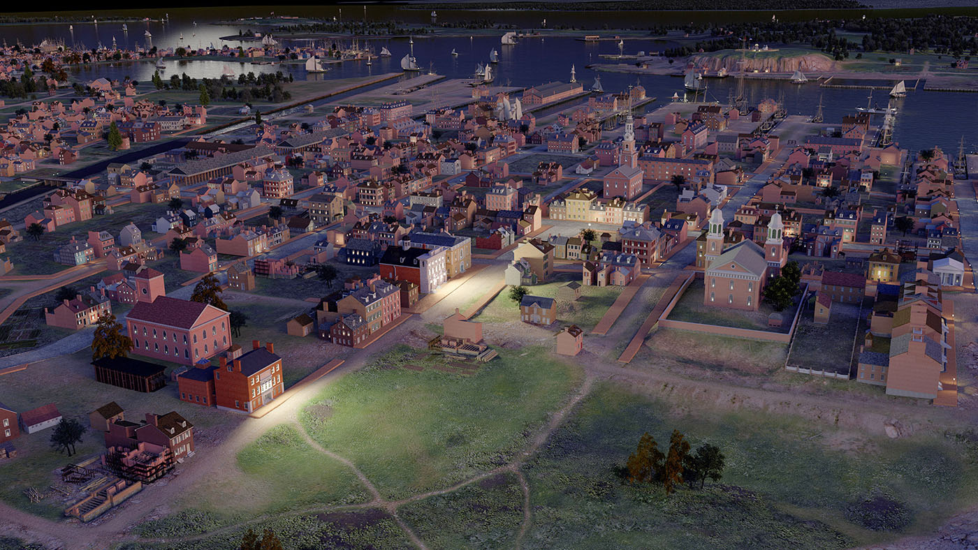
In 2016, the IRC created two illustrations of Baltimore for a book commemorating the 200th anniversary of the founding of the Baltimore Gas & Electric Company. The first image depicted the entire city and the surrounding countryside as it appeared in 1816 when BGE was first established. The second image, seen here, illustrated the effect that the first gas lamps had on the city when they were installed by Rembrandt Peale in the neighborhood surrounding the Peale Museum and the Holliday Street Theater.
Recent Project Updates
In 2016 the IRC created two illustrations of Baltimore for a book commemorating the 200th anniversary of the founding of the Baltimore Gas Electric Company. The first image depicted the entire city and the surrounding countryside as it appeared in 1816 when BGE was first established. The second image illustrated the effect that the first gas lamps had on the city when they were installed by Rembrandt Peale in the neighborhood surrounding the Peale Museum and the Holliday Street Theater.
The topical focus of the project extends beyond the war itself to the status of the fast-growing city of Baltimore at the height of its harbor industries in the beginning of the nineteenth century. With a topography and the foundations of a virtual environment in place, the IRC plans to seek further funding to augment the visualization and develop stories about the early city, to engage audiences with early Baltimore – a young, dynamic, and successful American city.
Researchers and Creators
Project Director: Dan Bailey
Project Manager/Lead Researcher/Modeler: Tamara Peters
Technical Director: Ryan Zuber
GIS/Cartography: Lindsay Previtt and Joshua Cole
Graphic and Web Programming: Shawn Squire and Mark Jarzynski
Historical Scholarship/Consulting: Mary Ellen Hayward and Lance Humphries
Modeler: Christina Jeresano
Additional Fort Modeling: Timothy Bubb
Students
GIS Assistants: Natalie Cheeto, Thomas Harvey, Cameron Smith
Undergraduate Student Interns: Rachael Birky, Wilfred Brownell, Drake Gao, Oliver Hill, Timothy Connell, Calvin Kumagai, Yan Lin, Robyn Lott, Megan Masciana, Brianna Paige, Jonathan Schubbe, Carly Sullivan, Paul Tschirgi, Ganna Vikhlyayeva
SUCCESS Student: Bianca Bouknight
Collaborators: Maryland Historical Society and UMBC’s Center for Urban Environmental Research and Education (CUERE)
Funding
Maryland Division of Tourism, 1812 Bicentennial Commission, Robert W. Deutsch Foundation, Maryland Historical Society
Contact
For information about the Visualizing Early Baltimore project:
Dan Bailey, Project Director
bailey@umbc.edu
410-455-2163
For information about the Maryland Historical Society:
The Maryland Historical Society
210 West Monument Street
Baltimore, MD 21201
For general information, hours, and directions:
410-685-3759
www.mdhs.org
For specific information about the BEARINGS of the Baltimore Project:
Kristin Schenning, Director of Education
kschenning@mdhs.org
410-685-3750 ext. 336
Images from Early Baltimore may be freely used with the following credit:
Image from “Visualizing Early Baltimore” by Dan Bailey and the Imaging Research Center, 2016. Courtesy of the IRC at UMBC.
If you use our image, please let us know: irc@umbc.edu