Interactive Touch Screen Display, Maryland Historical Society
September 13, 2014, marks the 200th anniversary of the major British attack on Baltimore. What was so important about Baltimore two hundred years ago? Over a few decades in the early nineteenth century, Baltimore’s population exploded, and it grew from a small town to the third-largest city in the young United States. What was the draw? After the British set fire to the city of Washington in 1814, they set their sights on Baltimore, which they considered a particular thorn in their side. Why?
The bicentennial of Maryland’s role in the War of 1812 has provided a catalyst for asking these historical questions as well as an opportunity for the IRC to use the experience gained from our Visualizing Early Washington, DC project to work on developing an accurate map and 3D depiction of the Baltimore cityscape circa 1815, shortly after the famous bombing of Fort McHenry that inspired the words of the U.S. National Anthem. With fundamental support from the Maryland Historical Society and its network of historical scholars, the IRC has been able to collect the data necessary to initiate the visualization. The research effort received major support from the Maryland Division of Tourism 1812 Bicentennial Commission and the Robert W. Deutsch Foundation and is currently on display at the Maryland Historical Society.
The IRC has spent two years researching how Baltimore would have looked circa 1815. Working with UMBC’s Center for Urban Environmental Research and Education (CUERE), the IRC created an accurate topography on which to build the city. It consulted local historical scholars and scoured documents relating to specific buildings to determine which structures existed back then and how they would have appeared. With that information, a team of IRC artists modeled and textured the buildings, wharves, and other structures that defined Baltimore during the economic and population boom that accompanied the height of the harbor’s role in commerce, privateering, and shipbuilding.
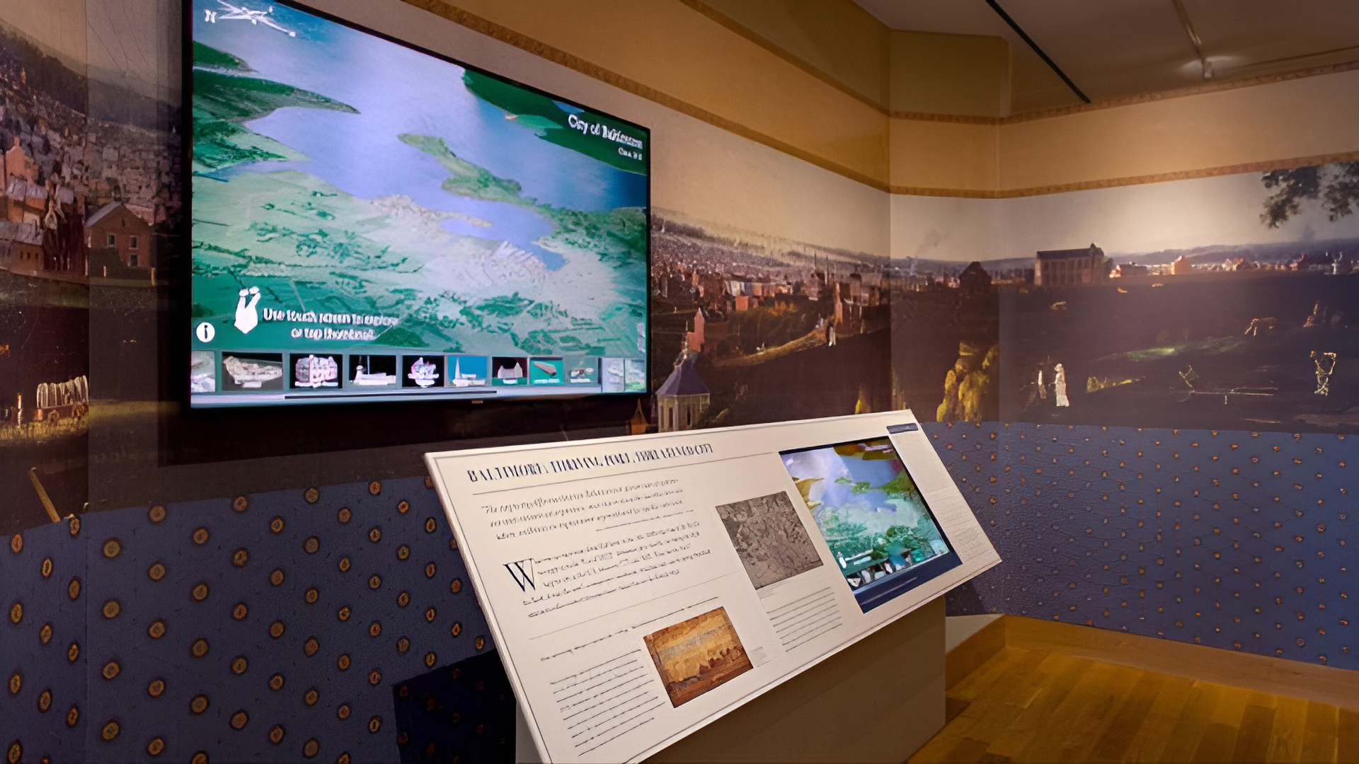
The result is a huge gigapixel image of a bird’s eye view of early Baltimore. IRC computer programmers have made this scene navigable by touchscreen to zoom into the vast details of the city. Certain hotspots, such as the home of Mary Pickersgill, the seamstress who sewed the famous ‘Star Spangled Banner’ for Fort McHenry, or the observatory atop Federal Hill signaling which merchant ships were headed to dock, can be located by tapping thumbnails and additional information and visuals provided by the Maryland Historical Society can be found by accessing pop-up windows.
This project, known as BEARINGS (Bird’s Eye Annotated Representational Image/Navigable Gigapixel Scene) of Baltimore, Circa 1815, is now on display at the Maryland Historical Society and available as an online tour.
Researchers and Creators
Project Directors: Dan Bailey, Imaging Research Center, UMBC, and Burt Kummerow, Maryland Historical Society
Primary Researcher and Project Lead: Tamara Peters
Technical Director: Ryan Zuber
Geographic Information Systems Specialists: Lindsay Previtt and Joshua Cole
Programmers: Mark Jarzynski and Shawn Squire
Senior Modeler: Christina Jeresano
Texture Artist: Ganna Vikhlyayeva
Text Content: Kristen Schenning and Debbie Harner, Maryland Historical Society
Scholars: Mary Ellen Hayward, Lance Humphries
2D and 3D Content Creation Assistants: Rachael Birky, Katherine Bobby, Bianca Bouknight, Wilfred Brownell, Timothy Bubb, Natalie Cheeto, Timothy Connell, Rachael Devore, Nathan Frankoff, Drake Gao, Thomas Harvey, Oliver Hill, Alison Holloway, Annette Horan, Calvin Kumagai, Yan Lin, Robyn Lott, Megan Masciana, Gloria Okafor, Brianna Paige, Nicolette Riggin, Joseph Rogoroso, Shelly Ryan, Ben Schaffer, Jonathan Schubbe, Cameron Smith, Carly Sullivan, Paul Tschirgi, Andrea Wozniak
Funding
Maryland Division of Tourism, 1812 Bicentennial Commission
Robert W. Deutsch Foundation
BGE, Baltimore Gas and Electric (an Exelon Company)
This ongoing project to visualize early Baltimore is being conducted at UMBC’s Imaging Research Center (IRC) with the help of faculty, staff, and students. Collaborating organizations are the Maryland Historical Society and the Center for Urban Environmental Research and Education (CUERE), UMBC.
Imaging Research Center, UMBC © 2024